|
| *****SWAAG_ID***** | 453 |
| Date Entered | 05/02/2012 |
| Updated on | 07/04/2012 |
| Recorded by | Tim Laurie |
| Category | Geological Record |
| Record Type | Geological HER |
| Site Access | Public Access Land |
| Record Date | 03/02/2012 |
| Location | Winterings Low Scar |
| Civil Parish | Melbecks |
| Brit. National Grid | SD 9490 9962 |
| Altitude | 470m |
| Geology | Underset chert faulted down against Underset Limestone. |
| Record Name | Winterings Low Scar. Faulted chert and limestone strata. |
| Record Description | This visible fractured strata at Winterings Low Scar is one of a number of mineralised faults which have been worked for lead above Winterings through the centuries. Here, chert strata normally above the Underset Limestone are visibly dragged down at an angle of around 40 degrees hard against strata of the Underset Limestone. |
| Additional Notes | To follow. |
| Image 1 ID | 2243 Click image to enlarge |
| Image 1 Description | The faulted limestone strata at Low Scar, Winterings. | 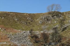 |
